Monday, November 16, 2015

Steering And Navigation - Eyeball and Electronics

Steering and navigation on a trip like this - primarily in rivers and canals - seems fairly straightforward.

Turn the wheel left and right to move the bow and keep in the center of the river by eye, steer to pass between the buoys marking the river or channel and that's about it for many miles at a time.  There are bends and narrow channels to navigate through or locks to approach and depart, but it is mostly not rocket science.

There is a bit more to know, however, when you consider that there are boats to approach from astern and pass, ones to meet and pass and the variables of size, speed, maneuverability and the absolute wild card of visibility.  If there is nobody coming at your or to pass and you can't see, it hardly matters.

But if there is traffic and you have other boats and limited visibility, what do you do?

That's where having a well-equipped boat comes in.  Dutchess has two GPS chart plotters, radar and other instruments that tell us exactly where we are, how fast we are going and (this is newly evolving and absolutely amazing) provides information on other craft - particularly large commercial vessels which includes to often 1000' tows (tug and up to 15 barges).

Another benefit uf using the chart plotters to supplement your eyeball view forward is that the moving map display can show you what is around the next bend.  Is is a long, straight section or does it make a series of S turns?


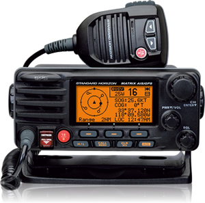
There is also a VHF radio which we can use for voice contact with other vessels.

In this case, the Standard Horizon GX-2200 provides some crucial additional functions.  With a built in GPS and AIS receiver, it provides information that is shown on the radio display (and remote microphone display) and is also sent to one of the chart plotters to provide information (and allow direct communication) with other vessels.

As a refresher, the buoy marker system has primarily red and green buoys which mark channels and provide the path to navigate.  There is a rule:  "Red, Right Returning" which means when returning from the sea you keep the Red buoy to starboard and Green to port and you are in the channel.  Obviously, this is reversed when you headed downriver (as we have been) so we keep the Red to port (our left) and the Green to Starboard (our right).  We do this visually or we use the instruments.
This is the binnacle which houses all of navigation instruments.  You will note that the steering wheel (helm) is partially shown at the bottom.


At the top is the magnetic compass.

In the center is the main (Simrad) chart plotter

On the Simrad we have the Speed Over Ground (SOG) which tells us how fast we are going (Knots or Nautical Miles Per Hour) with respect to land - 5.8K is shown.  If we are making 6K but into a 3K current, our SOG is only 3K.  But, if we have the current following, we make 6K while the entire body of water moves at 3K.  Our SOG (how fast we move by the riverbank) is 9K!

Our COG is to the right which shows our current Course Over Ground. This is shown in magnetic course degrees.

Next we have current Latitude & Longitude, shown in Degrees, Minutes and Decimal Minutes.

Depth below our keel (in feet), current time and an icon that shows we are receiving enough satellite information for a reliable position.  

If you look at this screen closely, you will see that there is a graphical position of where we are (the little black boat) the shape of the channel, a solid line to show where the edge of the channel is (beyond which is "thin water) and the sailing line which is usually (but not always) the center of the channel.  While detail outside of the river channel is limited, intersections of bays, creeks and other rivers is always clearly shown.

This sailing line is accurate enough that (in theory) you could stay on it and not stray into shallow water.  But, that doesn't prevent you from having a collision with another boat.

The sailing line on the chart is an invaluable tool when operating in reduced visibility. 

When we have operated in conditions with limited forward visibility, I have often brought my Samsung Notepad (like a small IPad) with the Navionics navigation program) with me to the bow.  In that position, I can look for nearby obstacles that we would normally see from the cockpit (primarily floating logs) and can verify that the helmsman is holding the sailing line in sufficiently close tolerance.

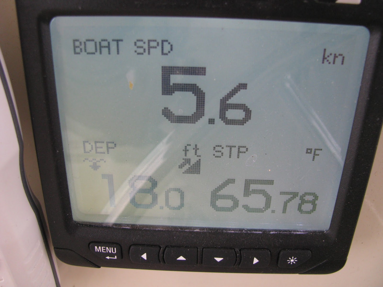
Here is our autopilot control display which shows our current magnetic course, magnetic heading, rudder position (currently 2 degrees starboard and speed through the water (5.6K).

The "A" preceding the course shows that we have the autopilot engaged.  In this position, (since we have hydraulic steering) turning the helm (wheel) has no effect.

Since we have 5.8K SOG and 5.6K Boat Speed, we obviously have a .2K current gain (following current).

This separate indicator gives us a backup indication of depth, boat speed and also shows surface temperature.


This Garmin unit is a separate chart plotter (which could also give us depth if a transducer was installed - seem missing depth information), but does provide our SOG, COG, position, sailing line and chart information.
Its most important function is to provide us with AIS targets.  AIS (Automatic Identification System) on Dutchess is "Receive Only"  That means that, while we don't send out a signal, we can receive the signal sent by others through our Standard Horizon VHF radio (GX-2200) and display here.

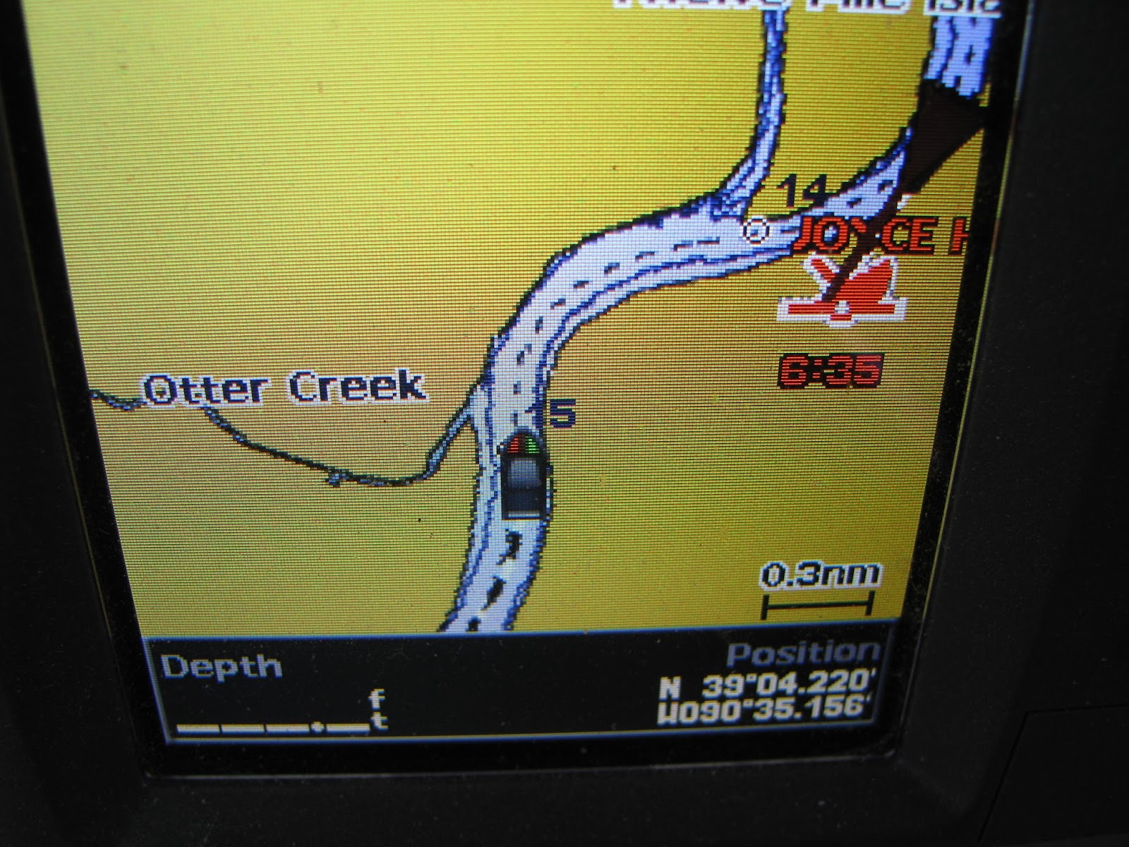
Since all commercial vessels are required to have a Type A AIS transponder, we can see target information on oncoming (or approaching from rear) commercial craft including tows with barges.

It is not line of sight (like radar) and allows us to see around bends in the river.  The AIS transponder gathers all information needed and broadcasts it continuously for reception by any craft with AIS reception capabilities.

The large Black triangle, Red boat name, collision target and time to collision gives us important information about oncoming traffic.  In this case, with our current speed and the speed of "JOYCE HALE", a collision in 6 minutes and 35 seconds is predicted.
If we toggle the display to the details page for this particular target, it provides us with all of the valuable information shown on these two screens.  While we could hail them by name on channel 16, this system allows us to call "bridge to bridge" and talk to them directly.

In most cases, we simply call, report our position and suggest a meet and pass action like this:  "Joyce Hale, Joyce Hale, Sailing Vessel Duchess, over"  When he responds, we continue:  "Yes, sir.  We are downbound (going downriver ) about 3/4 miles ahead and would to pass on your TWO."  This goes back to the days when radios didn't exist and everything was done with horn signals.  Pass on the ONE means to meet him Port side to Port side.  On the TWO means Starboard to Starboard.  When he responds to affirm, we move slightly to the port side of the sailing line and, when we have a visual, meet him as arranged.

This is a very important safety procedures since these large tows will often skew their course way over to one side to negotiate a sharp river bend and will know if they want you on their Port or Starboard side after you make contact.
In this case, we requested to pass on THE TWO (Starboard to Starboard).  He acknowledged and, when he came around the bend, we saw that he had a total 14 barges!


While not shown, Dutchess also has a 4G Broadband Radar which can be displayed either full or split screen on the Simrad display.  

While radar can be very useful in limited visibility situations, it would not have been helpful here until this huge target appeared around the bend.

Friday, November 13, 2015

6 Weeks, 7 States, 25 Locks, 1200 Miles, Countless Memories

When you make a journey like this, there is really no adequate way to summarize other than to reflect on what streams into your conciousness.

There were familiar tasks and some sights, but mostly everything was brand new.  First, spending over 40 days with two strangers is neither easy or without stresses and compromises.  Yet, in retrospect, I think we all did an admirable job.  When you rarely get more than 10 feet away from those who have irritated you or pissed you off, you learn to suck it up, put things into perspective and shrug it off as you begin a new day.


I've been in every one of these states before, but never saw anything I saw on this trip.  It was examining the chunks of  IN, IL, MO, KY, TN, MS and AL with fresh eyes.

Bald Eagles, Blue Herons, Egrets, Buzzards, Vultures, White Pelicans, Brown Pelicans and countless other birds were part of daily life.  Seeing a deer drinking by the riverside, hearing coyotes howling in the wild in an anchorage and sharing the water with Asian Carp, Alligators and Water Moccasins were all taken in with a sense of both marvel and comfortable acceptance.

I was not in my world; I was living in another world that few ever see.  I went from the 577 (MSL) foot elevation of Lake Michigan to sea level ( 0 MSL)  by stepping through 25 locks.

Adding up all of the mileage segments comes to over 1200 statute miles and I marvelled at both the boring sameness and amazing diversity of what I saw as the riverbanks went by at 6-12 miles per hour.

I was dry, wet, hot, cold, basking in the sun and shivering in the fog.  I maneuvered this fine 38,000 pound craft into and out of anchorages and docks, around river debris and stood at the helm for countless hours and hundreds of miles hand steering and tweaking the autopilot wheel control.

I cooked, washed dishes and (yes dear) made my bed every morning!  Along with the view from the boat, I covered nearly every mile of the trip with the navigation program on my tablet and kept electronic track journals of nearly the whole trip.

I'm home with my memories but would do the same trip again in a heartbeat in my own boat.  And, I'd continue on the other 4,800 miles of "The Loop" looking forward to "Crossing My Wake" at the Muskegon Pier Head.

I'm grateful and feel very fortunate to have made a journey this unique.  There is no question that, while I'm delighted to be home again and easing into the routine of fall and winter, there is a new sense of adventure and longing that has been uncovered.

Saturday, November 7, 2015

Riding On The City of New Orleans

Let the good times roll!

From New Orleans Amtrak station entrance to board the train.


The song "City of New Orleans" may be associated with Arlo Gutherie or Willie Nelson who both made hits of it, or the many other artists who have covered it.  But, the writer and original performer was songwriter Steve Goodman of Chicago in 1971.

It has special significance for me because Jimmy Buffet performed it during his historic Wrigley Field concert in 2005 while Hurricane Katrina devastated New Orleans.  At the time, we were operating a tour boat on Gun Lake and doing a live Jimmy Buffet concert through Sirius radio.

Needing the get back from the Gulf Coast, I found that this would be a unique way to get home. This train runs twice a day, every day, from the station in downtown NOLA to Union Station in the heart of Chicago.

Captain John drove me over from Mobile on Saturday morning and I spent three hours in the station and 21 more riding the rails back to Union Station.  A short cab ride brought me to Millenium Station and I took the South Shore line back to Dune Park in Chesterton, IN where Vickie picked me up.

While I found it hard to get to sleep in the wee hours, the ride was very pleasant and gave me a view of small town America that few others ever get to see.

Here is Steve Goodman performing the song:


Thursday, November 5, 2015

Alabama River Cutoff to Dog River (Turner Marine)


CSX lift bridge at mile 14 (14 miles North of Mobile Bay).  While most of these are normally lifted when an oncoming train is not present, we had to call this one and wait for the train to pass.  When a train is present, the center part of the bridge lowers to line up with the spans on either side.  In that position, we could not go below the bridge as there was only 5 feet of clearance.

When we called on the radio and let the bridge operator know that we were waiting for the train, he arranged to lift the bridge as soon as the train was clear.  Now, it is in the "UP" position and we have 35 feet or more of vertical clearance.
Leaving Mobile River to enter Mobile Bay - entering shipping channel.


Looking back from Mobile Bay entrance to downtown, shipping docks and shipbuilding areas.
Coming in from channel to Turner marine .


Wednesday, November 4, 2015

Views Inside A Lock

This is what you see in the lock as you lock through.  In this case, we have come into the lock and will be lowered about 35 feet to the level of the river on the other side of the doors ahead.

Please note the dark area on the lock side and on the doors in the background.  This dark area (recently wet) will get larger and larger until the water level has been dropped to the same as on the other side of the forward doors.  

Then, the doors open and we exit at the new level.  Anyone coming in the opposite direction can now come in, the doors will close, the water level will be pumped up the required 30 feet and the process is reversed in a new direction.


Bobby's Fish Camp to Alabama River Cutoff

When we pulled into Bobby's, we knew that we were spending the night, but thought that we would likely miss out on the reported great cooking at the restaurant.  You have to understand, this is a small dock in the absolute middle of nowhere; that's why most people stop since it is always easier to tie to a dock than anchor is some cutoff or creek.

The restaurant is closed except for Thursday through Saturday, but they will open and cook if they have 6 or more patrons.  They have a couple of excellent (and very experienced) cooks that live nearby and are on call for just this duty.

We laid around for a few hours and then this huge sport fishing craft (55' plus) pulled in with two guys that were (I am not making this up) on their way to attend a football game upriver in Tuscaloosa.  I guess if you can afford the boat and the fuel, why not blow a couple of grand on a weekend of debauchery and football!

By the time the sun went down, we had two more boats and plenty of people for an outstanding dinner.  The Captain chalks up this as the best meal of the trip!

We left the next morning for Coffeeville lock (the last lock and back to sea level and salt water) in pea-soup fog.  This is  not a joke; there was no forward visibiility!

But, due to the accuracy and reduncancy of our GPS and radar systems, we are able to safely move forward at a reduced cruise speed and find our way to the lock.  We follow one boat (which we never see until the lock) and have one follow us and we make it to the lock and in.

Unfortunately, this was the same mode of operation for a few more hours and then we were able to drone along for hours to the anchorage at Alabama River Cutoff.