Turn the wheel left and right to move the bow and keep in the center of the river by eye, steer to pass between the buoys marking the river or channel and that's about it for many miles at a time. There are bends and narrow channels to navigate through or locks to approach and depart, but it is mostly not rocket science.
There is a bit more to know, however, when you consider that there are boats to approach from astern and pass, ones to meet and pass and the variables of size, speed, maneuverability and the absolute wild card of visibility. If there is nobody coming at your or to pass and you can't see, it hardly matters.
But if there is traffic and you have other boats and limited visibility, what do you do?
That's where having a well-equipped boat comes in. Dutchess has two GPS chart plotters, radar and other instruments that tell us exactly where we are, how fast we are going and (this is newly evolving and absolutely amazing) provides information on other craft - particularly large commercial vessels which includes to often 1000' tows (tug and up to 15 barges).
Another benefit uf using the chart plotters to supplement your eyeball view forward is that the moving map display can show you what is around the next bend. Is is a long, straight section or does it make a series of S turns?

There is also a VHF radio which we can use for voice contact with other vessels.
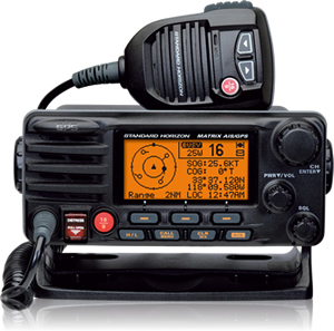
In this case, the Standard Horizon GX-2200 provides some crucial additional functions. With a built in GPS and AIS receiver, it provides information that is shown on the radio display (and remote microphone display) and is also sent to one of the chart plotters to provide information (and allow direct communication) with other vessels.
As a refresher, the buoy marker system has primarily red and green buoys which mark channels and provide the path to navigate. There is a rule: "Red, Right Returning" which means when returning from the sea you keep the Red buoy to starboard and Green to port and you are in the channel. Obviously, this is reversed when you headed downriver (as we have been) so we keep the Red to port (our left) and the Green to Starboard (our right). We do this visually or we use the instruments.
 |
Here is our autopilot control display which shows our current magnetic course, magnetic heading, rudder position (currently 2 degrees starboard and speed through the water (5.6K).
The "A" preceding the course shows that we have the autopilot engaged. In this position, (since we have hydraulic steering) turning the helm (wheel) has no effect.
Since we have 5.8K SOG and 5.6K Boat Speed, we obviously have a .2K current gain (following current).
|

Its most important function is to provide us with AIS targets. AIS (Automatic Identification System) on Dutchess is "Receive Only" That means that, while we don't send out a signal, we can receive the signal sent by others through our Standard Horizon VHF radio (GX-2200) and display here.
Since all commercial vessels are required to have a Type A AIS transponder, we can see target information on oncoming (or approaching from rear) commercial craft including tows with barges.
It is not line of sight (like radar) and allows us to see around bends in the river. The AIS transponder gathers all information needed and broadcasts it continuously for reception by any craft with AIS reception capabilities.
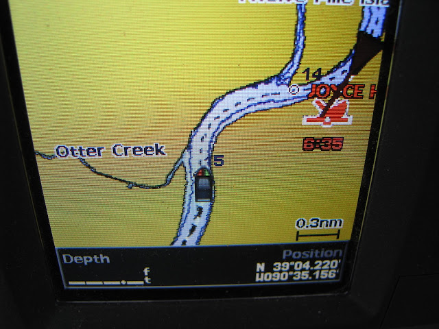
The large Black triangle, Red boat name, collision target and time to collision gives us important information about oncoming traffic. In this case, with our current speed and the speed of "JOYCE HALE", a collision in 6 minutes and 35 seconds is predicted.
If we toggle the display to the details page for this particular target, it provides us with all of the valuable information shown on these two screens. While we could hail them by name on channel 16, this system allows us to call "bridge to bridge" and talk to them directly.
In most cases, we simply call, report our position and suggest a meet and pass action like this: "Joyce Hale, Joyce Hale, Sailing Vessel Duchess, over" When he responds, we continue: "Yes, sir. We are downbound (going downriver ) about 3/4 miles ahead and would to pass on your TWO." This goes back to the days when radios didn't exist and everything was done with horn signals. Pass on the ONE means to meet him Port side to Port side. On the TWO means Starboard to Starboard. When he responds to affirm, we move slightly to the port side of the sailing line and, when we have a visual, meet him as arranged.
This is a very important safety procedures since these large tows will often skew their course way over to one side to negotiate a sharp river bend and will know if they want you on their Port or Starboard side after you make contact.
In this case, we requested to pass on THE TWO (Starboard to Starboard). He acknowledged and, when he came around the bend, we saw that he had a total 14 barges!

While radar can be very useful in limited visibility situations, it would not have been helpful here until this huge target appeared around the bend.


No comments:
Post a Comment